Potential Fields

Get the most out of your potential fields data with TechnoImaging®’s proprietary EMVision® software. Is your survey area extremely large? Does it have multiple components or even multiple types of potential fields data? Is there remanent magnetism? We can invert it.

Our Experience

We have experience with many systems, and have inverted all data types, including gravity, gravity gradiometry, magnetic, and magnetic gradiometry. Gravity and gravity gradiometry data or magnetic and magnetic gradiometry data are simultaneously inverted to produce the highest resolution geologic image with the least uncertainty. In areas with significant remanent magnetism, magnetic susceptibility and remanent magnetization are simultaneously recovered with our approach. We can also simultaneously consider both magnetic and gravity data with the Gramian approach to multimodal joint inversion and deliver multi-parameter models which satisfy both data sets.

Entire Brunswick Mining Camp is discretized to over 85 M cells. The figure shows horizontal section of 3D density model at 300 m depth produced by inversion of the FTG airborne survey.

No Limitations

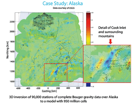
Extremely large potential fields present no problem for TechnoImaging®’s EMVision® software. The moving sensitivity domain approach allows our proprietary EMVision® software to handle virtually any size survey, with previous gravity inversions containing nearly 1 billion cells. The use of GPUs further accelerates the massively parallel inversion code. All inversions are performed with our patented focusing regularization, producing sharp, focused images and realistic parameter contrasts.

All models and data are delivered in industry-standard format. All processing is done on our powerful, secure, in-house cluster. Please contact us for more technical details, or refer to our peer-reviewed and refereed papers here.